
Geospatial & Location Sitemap
Verified GPS coordinates, driving proximities, and local travel directions across SSK Marina Bay Resort, Rameswaram Island, and the Ramanathapuram coastal corridor.
| # | Featured Image | Landmark & Proximity | GPS Coordinates | Physical Address | Location Details | Landing URL | Map Action |
|---|---|---|---|---|---|---|---|
| 1 |

|
SSK Marina Bay Resort Campus (Main Property)
Resort Campus
📍 0.0 km (Resort Property)
|
9.2625862, 79.0712823
Ramanathapuram, Tamil Nadu
|
Rameswaram Highway, Seeniappa Dharga, Sundaramudaiyan, Ramanathapuram, Tamil Nadu 623519 |
Main luxury resort campus featuring private plunge pool villas, ocean-view suites, beachfront dining, swimming pool, and event lawns on Rameswaram Highway. |
/
|
🗺️ Maps ↗ |
| 2 |

|
The Bayview Restaurant & Dining Pavilion
Dining
📍 0.0 km (Dining Wing)
|
9.26261, 79.07135
Ramanathapuram, Tamil Nadu
|
SSK Marina Bay Resort, Rameswaram Highway, Ramanathapuram, Tamil Nadu 623519 |
Signature seaside dining pavilion offering Ramnad fresh seafood catch, Chettinad specialties, and pure vegetarian thalis. |
/restaurant
|
🗺️ Maps ↗ |
| 3 |
|
Beachfront Swimming Pool & Private Shoreline
Resort Campus
📍 0.0 km (Beachfront Zone)
|
9.2627, 79.07142
Ramanathapuram, Tamil Nadu
|
SSK Marina Bay Resort, Bay of Bengal Shoreline, Ramanathapuram, Tamil Nadu 623519 |
Sprawling ocean-facing outdoor swimming pool with private beach sun deck, loungers, and kids splash area facing the Bay of Bengal. |
/swimming-pool
|
🗺️ Maps ↗ |
| 4 |
.jpeg)
|
Grand Oceanfront Banquet Hall & Lawns
Events
📍 0.0 km (Events Pavilion)
|
9.26255, 79.07125
Ramanathapuram, Tamil Nadu
|
SSK Marina Bay Resort, Rameswaram Highway, Ramanathapuram, Tamil Nadu 623519 |
Fully air-conditioned luxury event hall and landscaped waterfront lawns hosting destination weddings, corporate summits, and celebrations. |
/banquet-hall
|
🗺️ Maps ↗ |
| 5 |
|
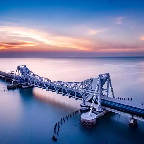
Historic Pamban Cantilever Sea Bridge & Lift Span
Historic Landmark
📍 7.2 km East of Resort
|
9.2785, 79.2064
Mandapam, Tamil Nadu
|
Pamban Channel, National Highway 87, Mandapam / Pamban, Tamil Nadu 623521 |
India's historic 1914 railway sea bridge with Scherzer rolling lift span, connecting mainland Mandapam to Rameswaram Island across the ocean. |
/destinations/pamban-bridge
|
🗺️ Maps ↗ |
| 6 |

|
Sri Ramanathaswamy Jyotirlinga Temple & 22 Theerthams
Pilgrimage
📍 12.5 km East of Resort
|
9.2881, 79.3174
Rameswaram, Tamil Nadu
|
Rannidhi St, Rameswaram, Tamil Nadu 623526 |
Ancient Jyotirlinga pilgrimage temple renowned for its 1,212 third-corridor pillars, sacred 22 theertham wells, and purification rituals. |
/destinations/ramanathaswamy-temple
|
🗺️ Maps ↗ |
| 7 |

|
Agni Theertham Sacred Sea Bathing Shore
Pilgrimage
📍 12.8 km East of Resort
|
9.2886, 79.3195
Rameswaram, Tamil Nadu
|
Agni Theertham Beachfront, East of Ramanathaswamy Temple, Rameswaram 623526 |
Sacred coastal beach east of Ramanathaswamy Temple where pilgrims take the purification holy dip and perform ancestral ceremonies. |
/destinations/agni-theertham
|
🗺️ Maps ↗ |
| 8 |
|
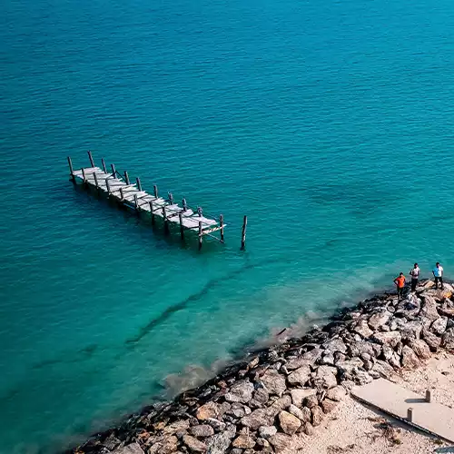
Dhanushkodi Ghost Town & Arichal Munai (Land's End)
Natural Landmark
📍 28.5 km Southeast of Resort
|
9.1764, 79.4447
Dhanushkodi, Tamil Nadu
|
Arichal Munai, Southern Tip of Rameswaram Island, Tamil Nadu 623526 |
The southernmost tip of Rameswaram Island where the Bay of Bengal meets the Indian Ocean, featuring 1964 cyclone ruins and Ram Setu viewpoints. |
/destinations/dhanushkodi
|
🗺️ Maps ↗ |
| 9 |

|
Dr. APJ Abdul Kalam National Memorial
Heritage & Culture
📍 9.1 km East of Resort
|
9.2817, 79.2872
Rameswaram, Tamil Nadu
|
Pei Karumbu, Rameswaram Highway (NH 87), Rameswaram, Tamil Nadu 623526 |
Grand national memorial built by DRDO honoring India's 11th President, featuring life exhibits, replicas of rockets, and landscaped gardens. |
/destinations/apj-abdul-kalam-memorial
|
🗺️ Maps ↗ |
| 10 |
|
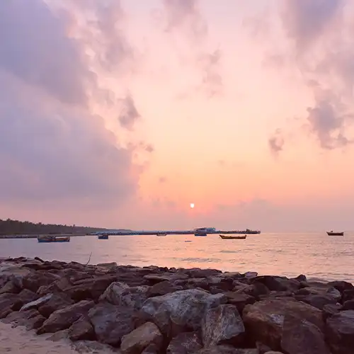
Kunthukal Beach & Vivekananda Memorial Hall
Beaches
📍 8.4 km South of Resort
|
9.2435, 79.2212
Pamban, Tamil Nadu
|
Kunthukal Coastal Road, Pamban Island, Tamil Nadu 623521 |
Shallow crystal-clear waters where Swami Vivekananda landed in 1897 upon his return from the West, with boarding for Kurusadai Island. |
/destinations/kunthukal-beach
|
🗺️ Maps ↗ |
| 11 |

|
Ariyaman Beach Watersports & Casuarina Park
Beaches
📍 14.2 km West of Resort
|
9.3142, 78.9895
Mandapam, Tamil Nadu
|
Ariyaman Sea Shore, Near Sathirakudi / Mandapam, Ramanathapuram 623519 |
Gentle swimming beach with water scooters, parasailing, children's park, and shading casuarina tree groves. |
/destinations/ariyaman-beach
|
🗺️ Maps ↗ |
| 12 |

|
Gulf of Mannar Marine National Park & Kurusadai Coral Island
Marine Reserve
📍 7.8 km South of Resort
|
9.2486, 79.2085
Mandapam, Tamil Nadu
|
Gulf of Mannar Biosphere Jetty, Mandapam Forest Office, Tamil Nadu 623518 |
First marine biosphere reserve in South & Southeast Asia housing 21 uninhabited coral islands, seagrass beds, dugongs, and eco-boats. |
/destinations/gulf-of-mannar
|
🗺️ Maps ↗ |
| 13 |

|
Olaikuda Beach & Coral Sunrise Coast
Beaches
📍 15.1 km Northeast of Resort
|
9.2995, 79.3301
Rameswaram, Tamil Nadu
|
Olaikuda Village Coast, Northern Shore of Rameswaram Island 623526 |
Quiet coastal beach ideal for viewing flamingo migratory flocks, shallow coral reefs, and tranquil sunrise walks. |
/destinations/olaikuda-beach
|
🗺️ Maps ↗ |
| 14 |
.webp)
|
Mandapam Sea Shore Park & CMFRI Marine Research Aquarium
Natural Landmark
📍 4.5 km East of Resort
|
9.276, 79.1415
Mandapam, Tamil Nadu
|
Mandapam Coastal Strip, National Highway 87, Tamil Nadu 623518 |
Scenic mainland coastal park overlooking the Indian Ocean and Gulf of Mannar, adjacent to the Central Marine Fisheries Research Institute. |
/resort-in-mandapam
|
🗺️ Maps ↗ |
| 15 |
|
Ramanathapuram Heritage Center & Ramnad Palace (Raja Palace)
Heritage & Culture
📍 18.5 km West of Resort
|
9.3667, 78.8333
Ramanathapuram, Tamil Nadu
|
Ramalinga Vilasam Palace, Palace Road, Ramanathapuram, Tamil Nadu 623501 |
Historic seat of the Sethupathi kings who guarded the Sethu canal, showcasing magnificent 17th-century murals and royal arms. |
/resort-in-ramanathapuram
|
🗺️ Maps ↗ |
| 16 |
|
Locations KML Geographic Dataset (Google Earth / Maps)
KML Dataset
📍 0.0 km
|
9.2625862, 79.0712823
Ramanathapuram, Tamil Nadu
|
SSK Marina Bay Resort, Ramanathapuram, Tamil Nadu 623519 |
Official Keyhole Markup Language (KML) geospatial vector file compatible with Google Earth, Google Maps, and GIS spatial indexing. |
/locations.kml
|
🗺️ Maps ↗ |